
Let’s continue a bit more along the geology trail! After all geology is fun and interesting and many more should get insight into the subject – that’s at least what I think :-))
Linking geology to real life is a good way of showing how important geological knowledge actually is. Here comes a bit more of this – this time with a focus on another of ScandiVanadium‘s planned exploration targets. For those of you not familiar with ScandiVanadium: this is the company who has re-discovered that parts of the Alum shale in Skåne contain very high amounts of the element vanadium. Vanadium has recently gained more importance and interest because it can be used in so-called vanadium redox batteries (VRB) or vanadium redox flow batteries (VRFB), which allow storing sun and wind energy for later use.
Bergsstaten recently approved ScandiVanadium‘s latest work plan (May 8th, 2019) for coring close to Spjutstorp (license Killeröd 1) and Fågeltofta (license Fågeltofta 1) in Österlen. In an earlier text I wrote about the geology around Spjutstorp and Onslunda, so now it is time to look a bit closer into the situation around Fågeltofta.
Fågeltofta’s geology is very similar to that around Onslunda and Spjutstorp. The same rocks appear here and also the same type of glacial sediments, which means sediments deposited in connection with the melting of the last ice sheet. Let’s start again with the glacial sediments, which are at or close to the surface. The map below shows how these sediments are distributed on the surface in the area.
The blue colored area marks different types of glacial till (= morän in Swedish) and the green colored areas show fluvioglacial sand, gravel and stones. Till (= morän in Swedish) is the geological name for sediment material that had been released by the ice sheet when it started to melt some 18 000 to 16 000 years ago. There has been much confusing regarding the word morän, because it denotes both a land form (for example ändmorän, lateralmorän) and a sediment (morän) in Swedish. To avoid these confusions, which are important from a scientific perspective, scientists call a morän with the more appropriate terms glacial diamicton or a till. The green colored areas denote the occurrence of sediment deposited by rivers draining the ice sheet. In Swedish these sediments are – in general terms – called isälvssediment, and in English they are summarized under the term fluvio-glacial.
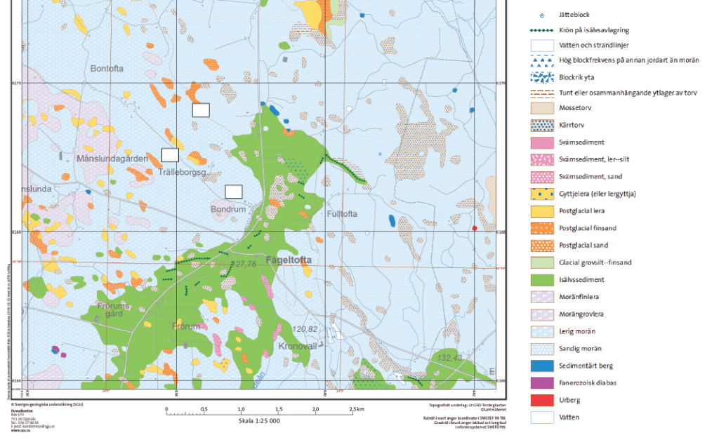
Much of the area around Fågeltofta is covered by glacial till (= morän), but there is also a larger complex with fluvioglacial sediments (= isälvssediment) extending from north of Fågeltofta further south. I guess that these sediments originate from when the ice sheet had melted and only big chunks of dead ice remained. Water circulating between the blocks of dead ice then accumulated all the sand, gravel and rounded stones.
Now let’s take a step further and look at the bedrock map for Fågeltofta, which shows how rocks of different ages are distributed below the glacial sediments. The geological map for Fågeltofta is actually very similar to that for Spjutstorp and Onslunda, the same rocks and very similar features.
I really like geological maps, because so much information can be gained from these. Now I will try and explain as much of the information as I can.
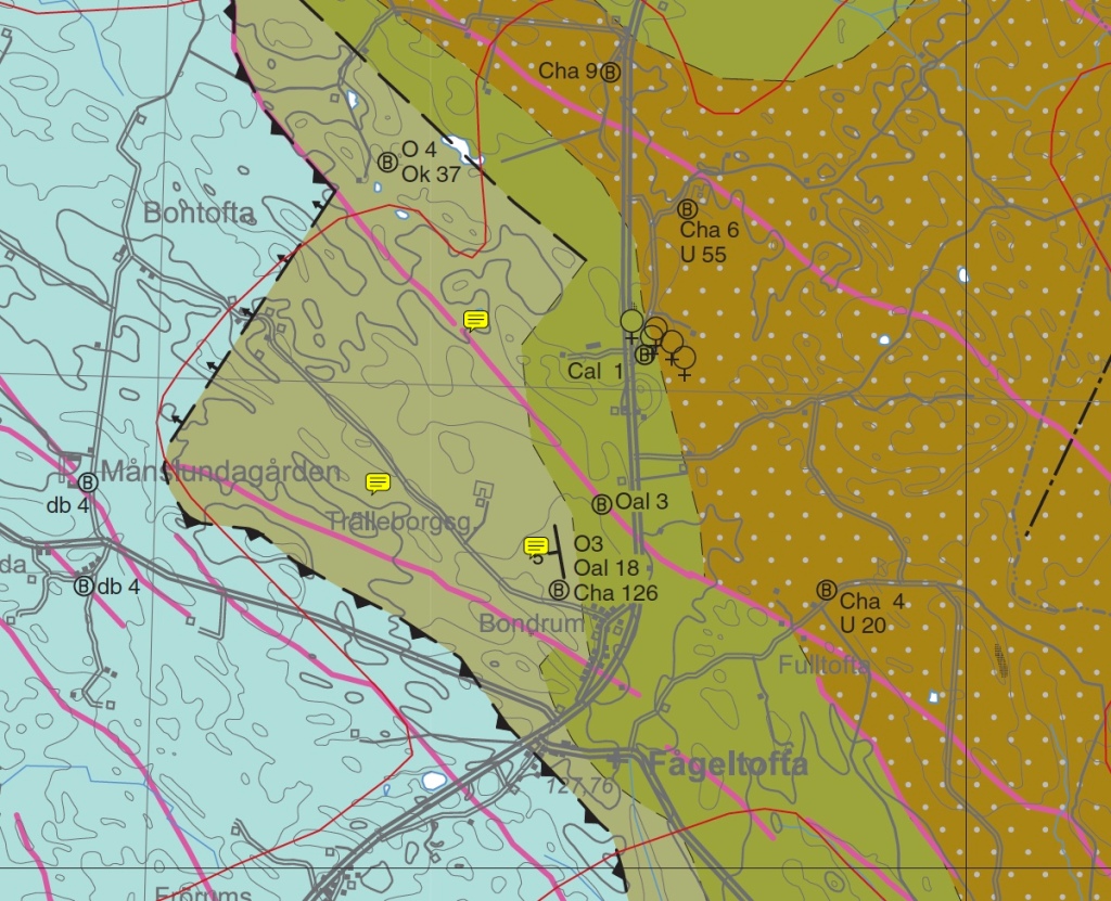
Copied from geological map AF 215 Berggrundskartan Tomelilla SO, Simrishamn SV, Ystad NO & Örnahusen NV issued by the Geological Survey of Sweden.
First of all, the different colors on the map above show the horizontal distribution of rocks of different ages. From left to right, we see the extension of quarzites and sandstones of lower Cambrian age (brown color with white spots); the next younger rocks are the Alum shales of middle Cambrian and lower Ordovician age (dark olive color); the lighter olive color marks the limestones, mudstones and shales of middle and upper Ordovician age and the blue color represents the youngest rocks here, the Silurian shales (blue color).
Secondly, the map also shows us that rocks younger than the Silurian shales are missing and must have been eroded. We can moreover see that where Ordovician and Cambrian rocks are close to the surface, all younger rock types must have been eroded. These had of course been present at some point, but erosion during hundreds of millions of years has led to their removal.
Thirdly, the map shows us that rocks older than the Silurian shales are very likely preserved below the blue colored area. This means that below the Silurian rocks we could find first limestones, mudstones and shales of upper and middle Ordovician age; below these latter we will find Alum shales of lower Ordovician and middle Cambrian age and below these quarzites and sandstones of lower Cambrian age. The reason why ScandiVanadium wants to core in the light olive colored area (upper and middle Ordovician) is that they suspect to find intact lower Ordovician age Alum shales below. Indeed the map tells us that lower Ordovician age Alum shales (Oal) can be found at a depth of about 18 m below glacial sediments.
This type of information has been obtained from well drillings (Brunnsarkivet) (marked as B in a circle on the map above). Well drillers provide important information for geological maps since they note the depth to bedrock and also the type of bedrock encountered at different depths. Thus when looking at the map above, we can for example see the signs B, Cha 4 and U 20 close to Fulltofta. This means that in the drilled well (B), quarzites and sandstones of lower Cambrian age (Cha) are at 4 m below the moraine and that the Precambrian bedrock (urberget) (U) is at 20 m depth. Similarly we can see that in a well (B) close to Bondrum, limestones, mudstones and shales of upper and middle Ordovician age (O) are at 3 m below the moraine, that the lower Ordovician age Alum shales (Oal) lies at 18 m depth and the quarzites and sandstones of lower Cambrian age (Cha) at 126 m depth.
What more does the geological map tell us? The dashed lines between rocks of different ages and the marked black line between the Silurian and Ordovician rocks show that significant tectonic movements have taken place. How these have influenced the rocks cannot be seen from the map, but I suspect that such tectonic movements could make the geological succession of the rocks a bit more complicated since larger rock packages could have been eroded. But let’s see what ScandiVanadium‘s drill cores will show.
I have not mentioned the purple colored lines on the geological map. These indicate the approximate location of dolerite/diabase dikes, which formed during Permian–Carboniferous time when magma from Earth’s interior intruded into older rocks. It is possible to get a more precise picture by looking at a geophysical map. This map, shown below, shows in red the extension of dolerite/diabase dikes.
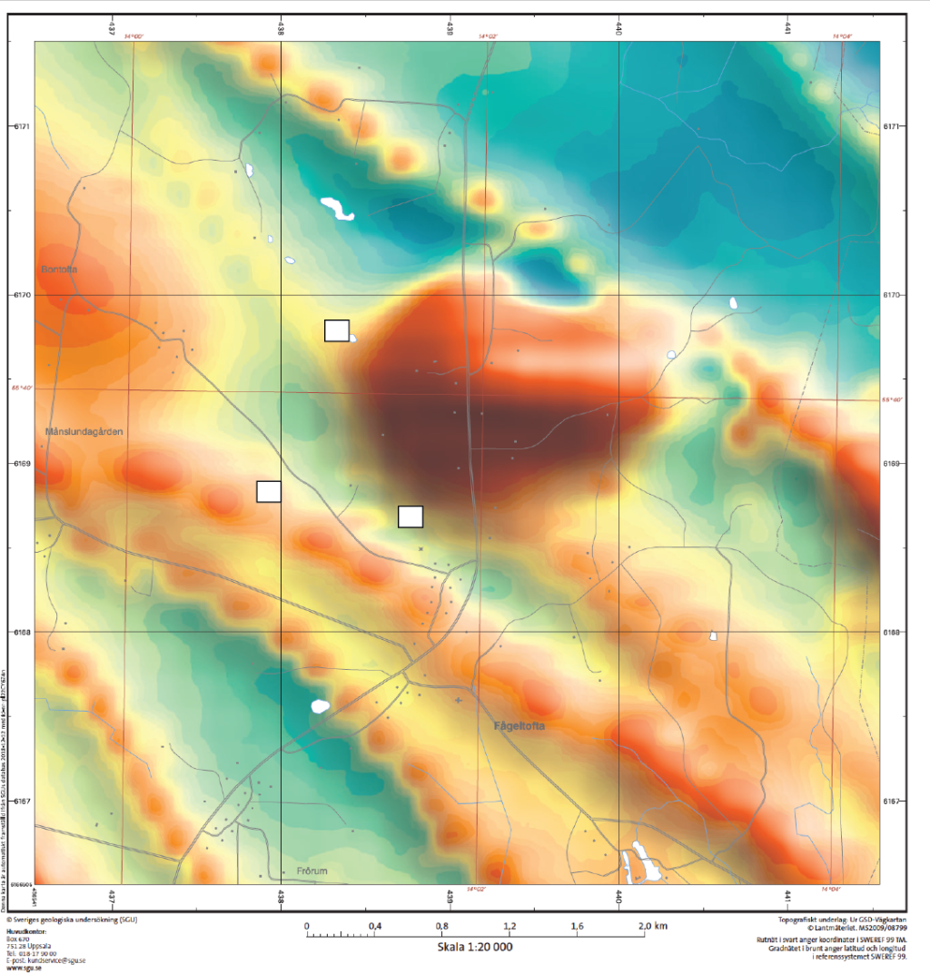
The approximate position of ScandiVanadium‘s drill cores is indicated by white rectangles.
Given that ScandiVanadium‘s drill cores are located close to these dolerite/diabase dikes, I would suggest that the company performs detailed geophysical investigations prior to coring. Otherwise the coring campaign could turn out as difficult as it seems to have been in Lybymosse. After all they are out there to find Alum shale and not any dolerite/diabase.

