
Recently, Bergsstaten – the Mining Inspectorate of Sweden – approved ScandiVanadium‘s latest work plan (May 8th, 2019) for coring close to Spjutstorp (license Killeröd 1) and Fågeltofta (license Fågeltofta 1) in Österlen. In its decision, the Mining Inspectorate writes that the planned drilling needs to be performed between February 25 and October 25 this year. Obviously it is possible to appeal this decision. But I am not really sure about how Bergsstaten‘s decision should be interpreted: does it mean that ScandiVanadium can start their coring right now or only after Mark- och Miljödomstolen in Växjö has dealt with the appeals? I guess that those who are impacted by ScandiVanadium‘s work plan will actually also appeal the decision.
For Spjutstorp/Killeröd 1, Bergsstaten has approved seven drill holes, in contrast to the 8-10 drill holes that were mentioned in ScandiVanadium‘s work plan, but had not been shown on the maps accompanying the work plan. For Fågeltofta 1, three drill core locations have been approved. As in their earlier work plans for Lybymosse, ScandiVanadium states that about 2-3 days will be needed to drill each hole. That this is an oversimplification has been shown by their drilling campaign in Lybymosse, which started in August last year and ended sometime in October. Drilling each hole in Lybymosse took much longer than the 2-3 days anticipated by the company. Why was this the case? Probably because ScandiVanadium did not do their home work well and had not read the existing geological literature.
Bergsstaten writes that the exploration work must be performed in accordance with what ScandiVanadium Ltd has stated in its work plan dated May 8th, 2019. In the work plan, ScandiVanadium writes that 1-2 months are needed for exploration in each area and that 2-3 days are needed to core one drill hole. But what happens if the work takes more than 2 months and drilling more than 3 days, as has been the case in Lybymosse? Will this still be in accordance with the working plan?
Although the whole issue may thus be pending until a decision has been reached by Mark- och Miljödomstolen in Växjö, I thought it would be timely to revisit the geology of the planned exploration areas. I will start with the geology around Spjutstorp and Onslunda and will write about Fågeltofta’s geology in a follow up text.
Let’s start with the surface geology, i.e. with the sediments above the bedrock. Most of the sediments in the area are glacial sediments, which means that they were deposited in connection with the last ice sheet. These are different types of till (= morän in Swedish) and glacifluvial sediments (= isälvssediment in Swedish). These sediments were deposited some 18 000-16 000 years ago, when the last ice sheet started to melt in the area.
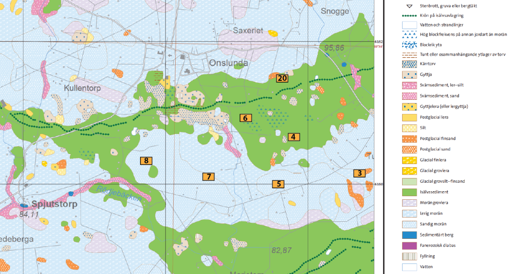
Unfortunately, the map above does not show the thickness of these sediments, but we can use the extensive documentation provided by well drillers (Brunnsarkivet). Many wells have been drilled in the area and their location is actually shown on the bedrock map below (marked by a B with a circle). The documentation tells us that the glacial sediments have a thickness of between 4 and 21 m and that below 4 to 21 m, we will find bedrock.
Of course, for mapping the geology in the area, the well documentation is of great help, because the well drillers also indicate which type of bedrock they have found at which depth, how deep they have drilled and where they have found groundwater and how much.
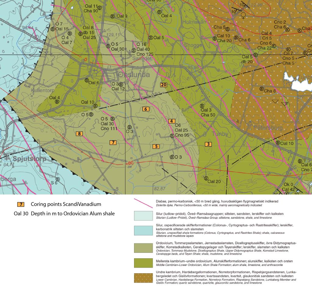
Copied from the geological map AF 215 Berggrundskartan Tomelilla SO, Simrishamn SV, Ystad NO & Örnahusen NV issued by the Geological Survey of Sweden.
The different colors on the geological map above show the different rock types and the ages of the respective rocks. Basically, from left to right, the rocks become successively older. The youngest rocks shown on the map are Silurian shales (blue color), the next older rocks are limestones, mudstones and shales of Ordovician age (light olive color) and next next older rocks are the Alum shales of lower Ordovician and middle Cambrian age (olive color). The oldest rocks are the quarzites and sandstones of lower Cambrian age (brown color with white spots).
The purple colored lines represent the approximate location of dolerite (diabase) dikes, which are much younger than the rocks. These dikes represent magma, which intruded into the older rocks some time during the Permian–Carboniferous, when Skåne experienced strong tectonic movements. The map also shows a marked deformation zone at the contact between the Silurian shales and the Ordovician rocks (black stippled line), which also originates from tectonic movements.
What one needs to imagine when looking at this map is, that older rocks are (almost always) found below younger rocks. Around Spjutstorp and below the blue colored Silurian shales, we will find limestones, mudstones and shales of Ordovician age and below these Alum shales of lower Ordovician and middle Cambrian age and below these quarzites and sandstones of lower Cambrian age. Further towards Onslunda limestones, mudstones and shales of Ordovician age are found, and below these are the Alum shales of lower Ordovician and middle Cambrian age and below these the quarzites and sandstones of lower Cambrian age, and so on. The map also shows us that much erosion has taken place. In an ideal case we would have the absolute youngest rocks all over the place and below these we would find a succession of continuously older rocks. But this is not the case. What we see on the map, is that only parts of the original succession of rocks are preserved. For example, everything that was deposited above the quarzites and sandstones of lower Cambrian age (brown with white dots) has been eroded. And everything that once had been deposited above the Alum shales of lower Ordovician and middle Cambrian age (olive color) has been eroded.
Focus of ScandiVanadium is on the lower Ordovician Alum shale (which the company stubbornly calls Dictyonema Formation) and which is known for its high content in vanadium. In order to obtain a full sequence of these shales and to understand the sequence of rocks, the company plans to drill through the limestones, mudstones and shales of Ordovician age, assuming that below these they will find the lower Ordovician Alum shale. Using the well drilling archive (Brunnsarkivet), we also know that these rocks (Oal) can be found at depths of between 12 and 30 m close to ScandiVanadium‘s anticipated coring points 4-8. But the company obviously also wants to core where the lower Ordovician and middle Cambrian Alum shale is closer to the surface (coring point 3).
All this seems pretty straight forward, but just looking at the bedrock types is not the whole story. It is also important to consider what happened to the rocks at a later stage.
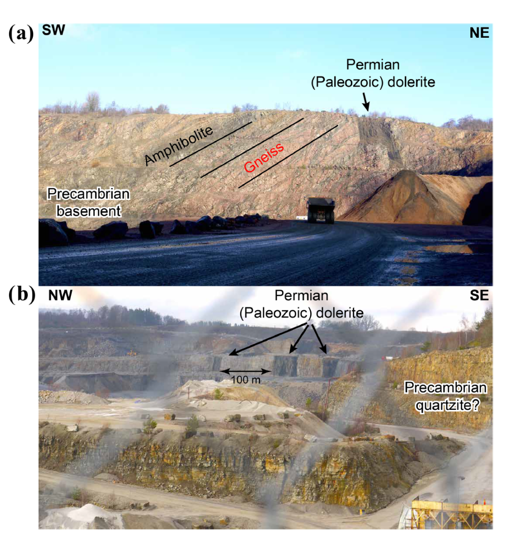
What happened was that during Permian–Carboniferous time magma from Earth’s interior intruded through these older rocks. These dolerite/diabase dikes therefore cut through the sandstone, limestone and shales (purple lines on the geological map), preferably along weaker zones in the overlying rocks.
The boundaries between a dolerite/diabase dike and the surrounding bedrock are often fractured zones, where water can easily percolate and reach underlying rocks. The contact zones between dolerite/diabase dikes and other rock types are therefore often also important zones for groundwater transport. And as such can be easily contaminated.
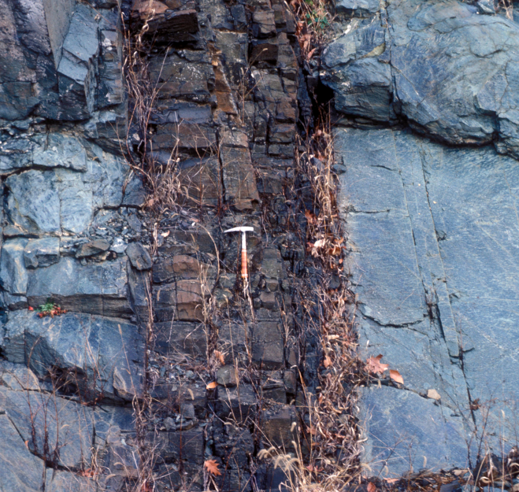
The sketch below illustrates what a dike can look like. Younger magma from deep inside the earth intrudes into older rocks and seeps into the different layers. The resulting sills and dike are what can today be found at the surface and also in deeper layers.

There are actually several of these dolerite/diabase dikes close to Onslunda. They have been mapped using geophysical instruments. The map below shows that ScandiVanadium‘s coring locations 8, 3, 4, and 6 seem to be positioned in close proximity to these dikes. It is of course not possible to say exactly where the dikes occur and how wide and deep they are using this map only. Their exact position should be determined with geophysical instruments prior to drilling.
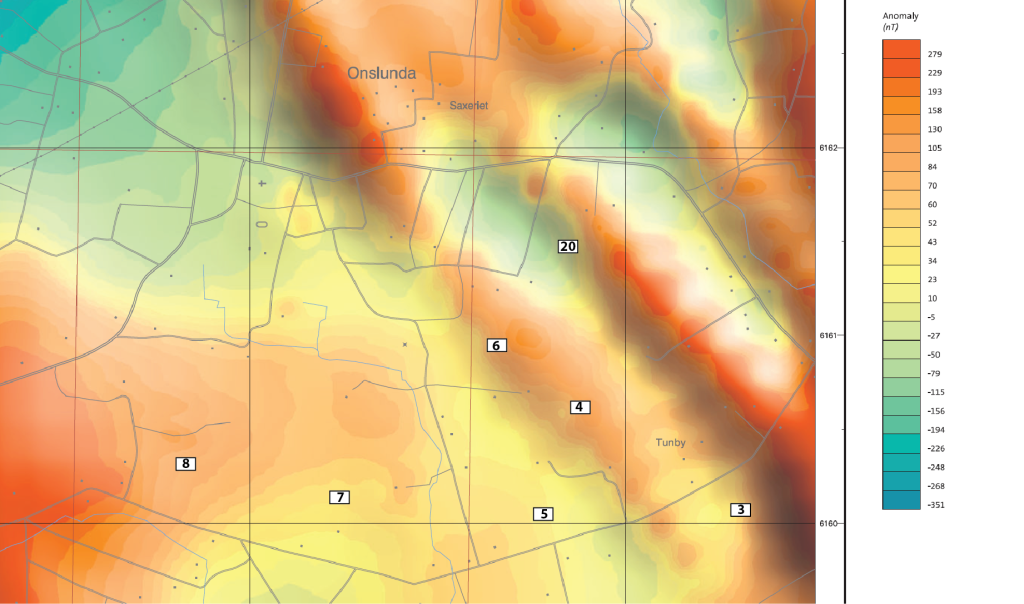
Drilling through a dolerite/diabase dike is not so simple. Avoiding dikes is a good idea, but it cannot be done before the vertical and horizontal extent of the dike has been mapped. I wonder if ScandiVanadium has any plans to map the dikes more exactly with geophysical instruments prior to drilling?
So much for today on geology!


Pingback: A look at Fågeltofta's geology | Barbara Wohlfarth